Fraunhofer Institute for Integrated Circuits IIS
Contact Press / Media
Konrad Dürrbeck
Head of Department »Innovation and Transformation«
Center for Applied Research on Supply Chain Services at Fraunhofer IIS
Nordostpark 84
90411 Nuremberg
Phone +49 911 58061-9516


There are over 6,700 active satellites in orbit. Half of these have been there for less than three years, and most were launched by private companies. New Space, that is the commercialization of space flight, is accelerating the development of increasingly powerful communication links. It is also laying the foundation for many new scientific projects thanks to exponential growth in high-resolution satellite imagery and spectral analyses in the infrared or radar wave regions. At the Center for Applied Research on Supply Chain Services, our researchers are already working on the development of new applications that will emerge thanks to New Space.
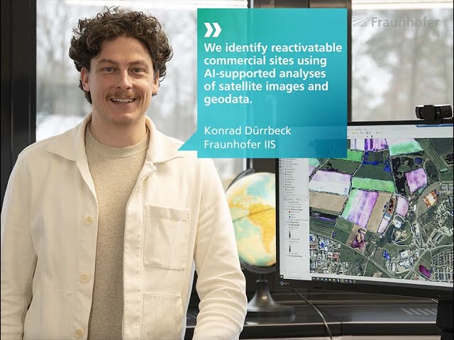
In the project "ARGOS – Reconnaissance of Reactivatable Brownfield Sites Using Optical-Based Systems", our Risk and Location Analysis department, for example, is working with real estate, logistics, and trading companies to develop an artificial intelligence (AI) for identifying corresponding sites. When it comes to identifying the abandoned sites known as brownfields, however, classical image recognition methods are inadequate. If a truck is visible in the photo of a site, for example, it could indicate that the site is in active use. On the other hand, it could simply be an old vehicle that has been parked there permanently. AI can help in situations such as these. "By using and combining additional data sources and analyses, we can achieve a high probability of obtaining a meaningful result," says project manager Konrad Dürrbeck. ARGOS also takes account of commercial register entries associated with plots of land and can now also incorporate infrared images that analyze moss coverage on roofs or vegetation on paved surfaces. Since the AI can analyze not only individual images but also chronological sequences, it is possible to dig deeper into the decision regarding a plot’s level of use. "The system marks the image features that it took into account in its decision so that the experts can better understand the AI’s judgment further down the line," says Dürrbeck. The advantage of this explainable AI method is that it allows better categorization of misjudgments in order to improve the system’s training.
From fall 2024 onward, the plan is to make the project results available in a register of brownfield sites on an online platform. Knowing the location of unused industrial sites will allow companies to use sites that have already been developed and save themselves the cost of new supply grids and connections to transport infrastructure. Reactivating sites such as these also represents a key contribution to the sustainability strategy for land use in Germany, which envisages reducing the current sealing rate of some 60 hectares per day to net zero by 2050.
Beyond searching for brownfield sites, the analysis of New Space data with AI opens up numerous possibilities. "We’re refining the system across the department so that we can benefit from New Space applications not only in wide-ranging location analyses but also in supply chain risk management and in our research focusing on civil security," says head of department engineer Dr. Roland Fischer. AI-assisted analyses of satellite data can detect disused railroad sidings that could be reactivated, for example, or monitor maritime trade routes in order to build greater resilience in supply chains. In disaster situations, AI-assisted analyses of satellite photographs and infrared images could provide vital additional details as the basis for more accurate and targeted action.