 Fraunhofer Institute for Integrated Circuits IIS
Regional Evacuation: Planning, Control and Adaption
Systematic Evacuation: Terrorist attacks, natural disasters, major fires – large-scale disasters can have numerous causes. The first and foremost priority of relief activities, however, is always the protection and rescue of people. The research project REPCA and the awiloc™ technology of Fraunhofer IIS are the starting point to bring people affected to safety faster and more efficiently.
50.000 people are in a panic and try to flee to trains, parking areas and designated rescue areas – an absolute horror scenario for any civil protection organization. The developers of evacuation plans and guidance systems which are effective in a disaster situation, have to pay attention to the following questions: Where do people run to, and who? Which routes do they take? Where can they find a point of safety?
For lifelike simulation the researchers need the real transaction data and human pathways. The project partners of the REPCA project dedicated themselves fully to the task: the University of Kaiserslautern, Arbeitskreis Notfallmanagement und Katastrophenschutz der Stadt Kaiserslautern (Kaiserslautern working group on emergency relief management and disaster control), Fraunhofer Institute for Integrated Circuits IIS and IT2media and Siemens. Project focus is on disaster evacuation as such and the scenario of a huge crowd that has just cleared a building and needs to be directed to safety.
Seamless Positioning with WLAN, GPS and GSM
Since almost everybody carries a cell phone or smartphone with them everywhere they go, it seems only logical to receive the data via a robust positioning technology for cell phones. Now awiloc comes into play, a Fraunhofer IIS technology for the autarkic positioning within cities and buildings, which in the research project REPKA combines positioning via WLAN, GPS and mobile radio. Autarkic – because the position can be calculated directly on the mobile terminal without any data communication.
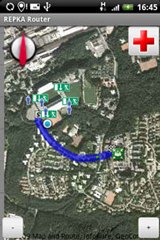
The positioning technology which is robust against failure and network congestion allows for a guidance system, which helps people to reach a safe refuge considering individual needs like disabilities. Based on the geographic information systems Map and Route, this individual guidance system was developed by project partner IT2media. The guidance system is based on the awiloc technology, which allows sending location-enhanced emergency calls, provides useful location information and facilitates reuniting friends and family outside the danger zone.
Innovations and Applications
A large-scale evacuation trial scheduled for 2011 will capture the crowd movement data around Fritz-Walter soccer stadium in Kaiserslautern. This exercise will provide the base data for a software library, which the rescue forces use for pre-emergency planning and rehearsing of many possible scenarios. The research into regional evacuation is tied in with related results from building evacuation and covers a major security gap since the evacuation of regions has so far been neglected. The technical innovations are tested for intelligibility and acceptance and accompanied by social-science based anxiety and panic research. The inclusion of all people concerned is at the core of the project, creating not solutions to individual problems but integrative system innovation. REPKA is funded by the German Federal Ministry of Education and Research BMBF in the framework of the research program ”Forschung für die zivile Sicherheit“ (research for civil security). Come and see how REPKA helps you to get to a safe place when in an emergency situation and find out more about awiloc: CeBIT 2010, hall 9, booth B36.