Precise Positioning for Industry

At a glance

© Fraunhofer IIS/Kurt Fuchs
Test- und Anwendungszentrum L.I.N.K.

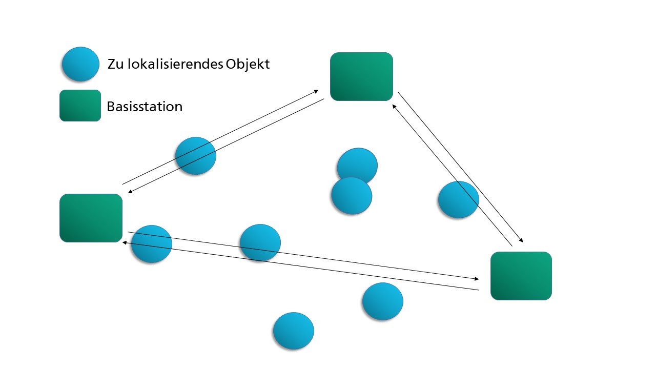
Fraunhofer IIS’s precise positioning for industry permits the rapid evaluation of positioning, communication and identification technologies. With the help of several integrated chipsets, we can determine and test the appropriate technology for your application. Fraunhofer IIS advises you on the introduction of technologies in your company. We can also provide you with a tailored all-in-one positioning solution or develop a solution adapted to your application.

Precise positioning for industry can be tailored to your requirements. Depending on those requirements, we can evaluate positioning, communication and identification technologies. This lets you select a technology that is tailored to your area size, desired accuracy, update rate or battery life. The evaluation also considers additional requirements such as size, price, time horizon and other parameters.

What we offer

Consultancy


Fraunhofer IIS has comprehensive technical and business know-how to assist you as you introduce positioning technologies. We have access to state-of-the-art measuring techniques and methods, to conveyor technology, as well as to an entire test center for simulating real application scenarios.

Evaluation and testing

We test and evaluate potential technical solutions for you under realistic conditions to check the technologies for their suitability. To this end, our L.I.N.K. facility offers you a test environment in which individual scenarios can be tested in detail and close to the application. Individual factors such as area size, transmitter characteristics, update rate or battery life are included in the process.

Customer-specific development

Fraunhofer IIS offers you all the expertise needed for a complete customer-specific system solution in the field of positioning, communication, identification and navigation. We conduct research and development work that is tailored to your business case, whether for new solutions or to adapt existing products. The basis for integrating the product is an individual license agreement aligned to your business model.

Technologies and expertise

RTT (Round Trip Time)
Uplink TDoA
Downlink TDoA

Positioning makes use of ultra-wideband (UWB) radio technology. Because this is based on short-duration pulses, it can achieve a very high time resolution. This in turn makes the system very robust against the effects of multipath propagation and ensures very high accuracy of the measured positions. Meanwhile, its large radio frequency bandwidth and simultaneously low signal power levels mean it does not disturb the spectrum and can coexist with other radio systems. Carrierless transmission simplifies the hardware design of UWB systems.


Different measuring principles are applied:

Round trip time (RTT):

This method calculates the location based on the time it takes for the signal to travel from the transmitter to the receiver and back again. This method is simple and delivers high accuracy.


Uplink time difference of arrival (TDoA):

TDoA supports a higher number of participants than RTT. This method uses triangulation to determine locations. The object to be located acts here as a transmitter to the pre-installed base stations, which are synchronized beforehand. Compared to Downlink TDoA, the number of objects to be located is limited by high utilization of the radio channel.


Downlink time difference of arrival (TDoA):

In contrast to uplink TDoA, here the base stations transmit to the objects to be located. This makes efficient use of the radio channel, as only a few base stations transmit a signal. As a result, any number of objects can be located with an average accuracy of a few centimeters.

Roundview

The Roundview system scans the angle of the signal and its distance. Vehicles fitted with Roundview can detect an object equipped with a tag anywhere in the room. Several strings of antennas attached to the vehicle scan the surroundings. They detect the tag and its distance and direction from the vehicle at any point, allowing the vehicle to follow the tag.

Adhoc is a self-calibrating UWB positioning system. Rather than having to be laboriously calibrated, anchors determine their position themselves. This permits the use of mobile anchors. Messages are sent to nodes that are not within range. The nodes are easy to configure. This communication concept is implemented on the Wismit platform, meaning the system is quick to set up and does not require any complex infrastructure. This makes it particularly suitable for dynamic applications such as construction sites.

The Wismit platform is hardware used in the rapid evaluation of positioning, communication and identification technologies. It can also serve as a basis for customer-specific developments in various areas. This platform enables the simultaneous use of different positioning technologies.

It comprises different communication components, such as positioning and communication chipsets with different frequency ranges (868 MHz, 2.4 GHz, 3.25–4.75 GHz or 4–6.5 GHz) and integrates different sensors (such as accelerometer or gyroscope), microcontrollers, and RFID or NFC. The credit card sized all-in-one platform has an interface to Raspberry Pi from version 4.4 onward and an inductive charging battery (Qi standard).

Strengths

  • System for comparative measurement and evaluation
    • Evaluation of different chipsets in special application scenarios
    • Technology consulting
    • Basis for system planning and sensor fusion
  • Small batches
  • All-in-one positioning solution
  • Fast adaptation to customer-specific application scenarios

Technical advantages

  • Different positioning technologies on one platform
  • Accuracy of approx. 10 cm
  • Tag is wirelessly rechargeable (QI standard)
  • Power supply for anchors via PoE
  • Leading positioning technologies on one platform

Applications and projects

Complete positioning of objects and persons enables maximum transparency for your processes. This results in potential uses in a wide range of industries.  

Wireless-based positioning systems are considered a key component of modern logistics systems. They pave the way for automated process monitoring based on time, location and scene. Demand is constantly growing for reliable, high-resolution and real-time object positioning and object identification inside and outside buildings.

The Wismit transceiver platform is versatile and its modular design allows it to be adapted to a wide range of requirements. Numerous Fraunhofer projects already use Wismits to implement positioning.


Areas of application:

  • Logistics: e.g. picking area
  • Industrie 4.0: e.g. production control
  • Internet of Things: e.g. container management
  • Sports: e.g. soccer
 

LocOn

Automatic access controls at airports.


Ko-Tag

The joint Ko-TAG project investigates wireless-based cooperative sensor technology for the protection of vulnerable road users.


Orat

Wireless-based positioning architecture that functions reliably even in difficult production environments.


RedFIR®

RedFIR® is an innovative wireless-based positioning technology that calculates the positions of people and objects in real time with a high degree of precision.


SECAIR

Combination of radio positioning and video technologies for the observation of vehicles, objects or persons to increase airport security.


EasyPilot

Efficient picking with JUNGHEINRICH’s easyPILOT Follow: Thanks to the precise positioning developed by Fraunhofer IIS, the picking vehicle automatically follows people and simplifies workflows during loading and unloading.


FlexLoc

Flexible positioning solution for automated production and logistics processes